About the INOVMineral Project
The Portuguese subsoil has great mining potential for strategic metals, either in the form of the main substance (in the case of Li, W or Sb) or as subproducts transformation of base metal ores (in the case of In, Se or Ge). To develop this potential, prospecting/research and mineral exploration must be supported by innovative methodologies, using disruptive technologies and scientifically oriented integrative models, in addition to environmentally and socially responsible management structures. The INOVMINERAL 4.0 project is funded by Portugal2020, Compete2020, Lisbon2020 and the European Regional Development Fund, with the general objective of reorienting innovative industrial models for the Mineral Resources Industry through the development of advanced technologies, new products and software that respond to all the value chain: upstream, enhancement of Mineral Resources and Market Place (client/market connection). Therefore, four segments (PPS) were developed to achieve the project's objectives, namely: PPS 1 - Circular Economy; PPS 2 - Digitization of Processes; PPS 3 - Collaborative Processes 4.0; PPS 4 - Stimulation and creation of skills (Fig. 1)
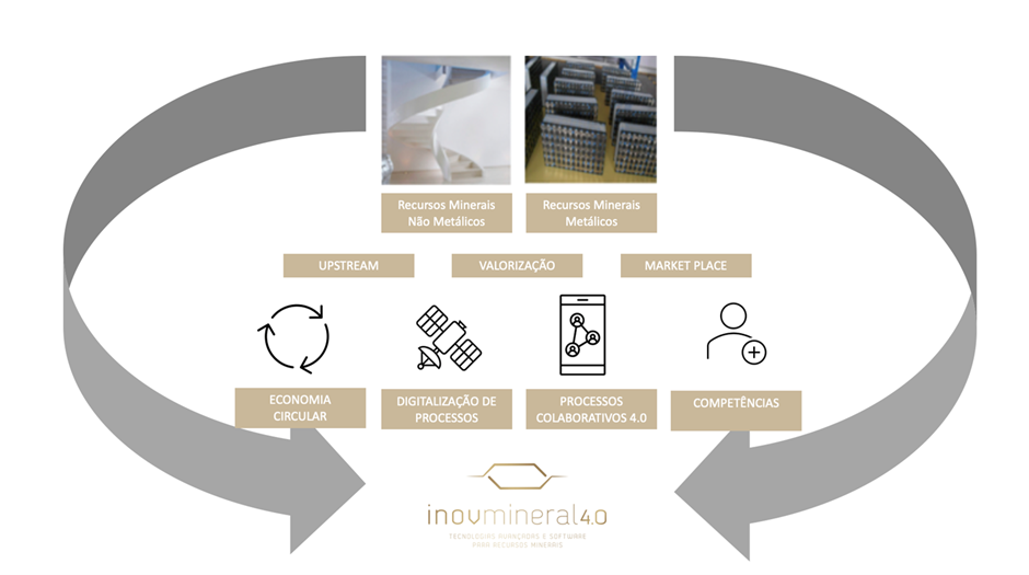
Figure 1. Main workflow of the INOVMINERAL 4.0 project.
The consortium is composed of the Faculty of Sciences of the University of Porto (FCUP) team, the Faculty of Sciences of the University of Lisbon (FCUL) team, and the Savannah Resources Inc company, which together integrate the PPS1 in the A7 activity of the INOVMINERAL 4.0 project. The objective of activity 7 is to contribute to the improvement of methods that allow delimiting the resource deposits, position the most favorable locations for drilling and blasting, and limit the number of samples sent to the laboratory, thus reducing costs for prospecting and exploration companies. In addition to cost reduction, the approaches planned in the project seek to obtain/process data that provide adequate information for the containment/mitigation of impacts inherent to the various stages of prospecting and exploration, contributing to the establishment of increasing levels of social acceptance of mining, since it tends to ensure that the full knowledge of the Lithium-bearing pegmatite mineral deposit can produce a residue close to zero, taking advantage of all the products and by-products of possible exploitation in the future. In general terms and, in the specific case of Lithium, the joint use of remote sensing, geophysical, geochemical, and Geographic Information System (GIS) techniques contribute to improving the knowledge of potential areas, reducing possible local impacts and allowing the establishment of priorities with implications: (i) on investment to be carried out in the stages before the start of exploration; (ii) in the selection of the most eco-efficient technologies for blasting and ore treatment, preferably with no waste production; (iii) in the life cycle of the mining operation; (iv) in the value chain of extracted raw materials, respecting the CP (Cleaner Production) principles; and (v) in the selection of methodologies to be used either in the monitoring of environmental impacts, or in their mitigation or remediation.
The research area is located in the Ribeira de Pena region, in an area known as Aldeia where Lithium-bearing pegmatite resources are under study. This aplite-pegmatite is part of the Mina do Barroso license. The LCT-pegmatite belongs to the Barroso-Alvão aplite-pegmatite field (BAPF) and the region has been studied for almost 40 years, including a national field exploration carried out by the Portuguese Geological Survey (LNEG). This attests to the existence of aplite-pegmatite dykes with economic potential for Lithium, namely through spodumene, lepidolite, petalite, and phosphates of the amblygonite series (Charoy et al., 2001; Lima, 2000).
Charoy, B., Noronha, F., and Lima, A. (2001). Spodumene - petalite - eucryptite: Mutual relationships and pattern of alteration in Li-rich aplite-pegmatite dykes from Northern Portugal. Canadian Mineralogist, 39(3), 729–746. https://doi.org/10.2113/gscanmin.39.3.729.
Lima, A. (2000). EStrutura, Mineralogia e Génese dos Filões Aplitopegmatítos com Espodumena da Região Barroso-Alvão. 300.
Therefore, the following works were carried out by FCUP's multidisciplinary team.
Remote Sensing
This method consists of the identification and determination of the characteristics of objects, places or phenomena based on the acquisition of images from sensors without direct contact with the studied target. Three classic image processing methods were applied to the multispectral images of Sentinel 2 and Landsat 8, 9 satellites. The proposed methods correspond to the combination of RGB bands, Band Ratios (BR), and Principal Component Analysis (PCA). These methods are widely used for lithological studies (Cardoso-Fernandes et al, 2019 ; Santos et al, 2019) that allow the improvement of contrasts and, consequently, highlight the element under study. For all satellite sensors, it is noticeable that PCA is the method that achieved the best results. This method was able to highlight the pegmatite pixels with high values, leaving it in evidence in relation to the other elements of the study area. The best PCA tested corresponds to bands 3 and 5 (Landsat 8, 9) and bands 3 and 8 (Sentinel 2). The combination of bands presents more false positives than PCA, but despite this, it correctly highlighted the Aldeia pegmatite under study. The combination of bands 7-3-11 (Landsat 8, 9) highlighted the pegmatite in yellow color and the surrounding elements in purple. The 3-2-12 combination (Sentinel 2) highlights the pixels that correspond to the white pegmatite very well and the other elements in bluish tones. BR has the highest number of false positives among the methods tested, requiring the addition of a vegetation mask to analyze the results. Despite being able to perfectly identify the pegmatite, the number of false positives negatively impacts the results of this method.
Cardoso-Fernandes, Joana, et al. “Remote Sensing Data in Lithium (Li) Exploration: A New Approach for the Detection of Li-Bearing Pegmatites.” International Journal of Applied Earth Observation and Geoinformation, vol. 76, no. October 2018, 2019, pp. 10–25, https://doi.org/10.1016/j.jag.2018.11.001.
Santos, Douglas, et al. Remote Sensing Techniques to Detect Areas with Potential for Lithium Exploration in Minas Gerais, Brazil. at the. 1, 2019, p. 50, https://doi.org/10.1117/12.2532744.
Photogrammetry
A Phantom 4 model drone was used to obtain the images used in photogrammetric restitution. The software used for the process was Agisoft Metashape, where the images were loaded and all the processing was carried out until obtaining the final product (Digital Surface Model (DSM) and Orthophoto). The process is based on the use of stereoscopy and uses computer vision algorithms to obtain common attributes between each pair of images. To obtain the maximum of common attributes, an overlap of 80% was used for the images. The first product generated was a point cloud, from which a mesh was generated by interpolation. Another product obtained was the orthophoto, which corresponds to a set of aerial images submitted to geometric corrections - orthorectification - in order to obtain a map with a uniform scale.
LiDAR
To obtain the LiDAR data, a DJI Matric 300 RTK model drone was used, with a DJI Zenmuse L1 sensor attached. The technique consists of emitting directed electromagnetic waves (Laser- 905 nm Wavelenght), and obtaining a reflected signal through a receiving sensor. Knowing the position of the instruments in the emission and reception of the signal, the distance is calculated and consequently, the point coordinates are obtained. To increase the accuracy of instrument position, the L1 sensor has an IMU (Inertial Measurement Unit), a unit that contains acceleration (accelerometer) and direction (gyroscope) sensors. The drone contains an RTK (Real Time Kinetic) system, which provides an even more accurate location estimation than conventional satellite navigation systems. The generated products were point clouds in the standard .las format of LiDAR sensors. The points obtained were processed in the LasTools software, software in which filters were applied to obtain the points corresponding to the ground, from which a DEM of the area was generated.
Geophysics
The methodology used was gamma-ray spectrometry with the Exploranium GR-320 enviSPEC equipment. This method is used to measure the radiation sources of a given material. The main sources of gamma radiation detected at the Earth's surface come from the natural disintegration of potassium (40K %) and the elements of the series of uranium (238U ppm) and thorium (232Th ppm). The use of this method in the Aldeia region was useful because the pegmatite contains less thorium than the shale (host rock), thus being able to make a distinguishment between the two. In this method, it is possible to analyze outcropping or semi-outcropping materials as they detect 30-40 cm of soil. Readings were made every 5 meters on the open paths and near the drilling platforms. Subsequently, the data were processed and processed in ArcGIS Pro to produce a radiometric map as the final product.