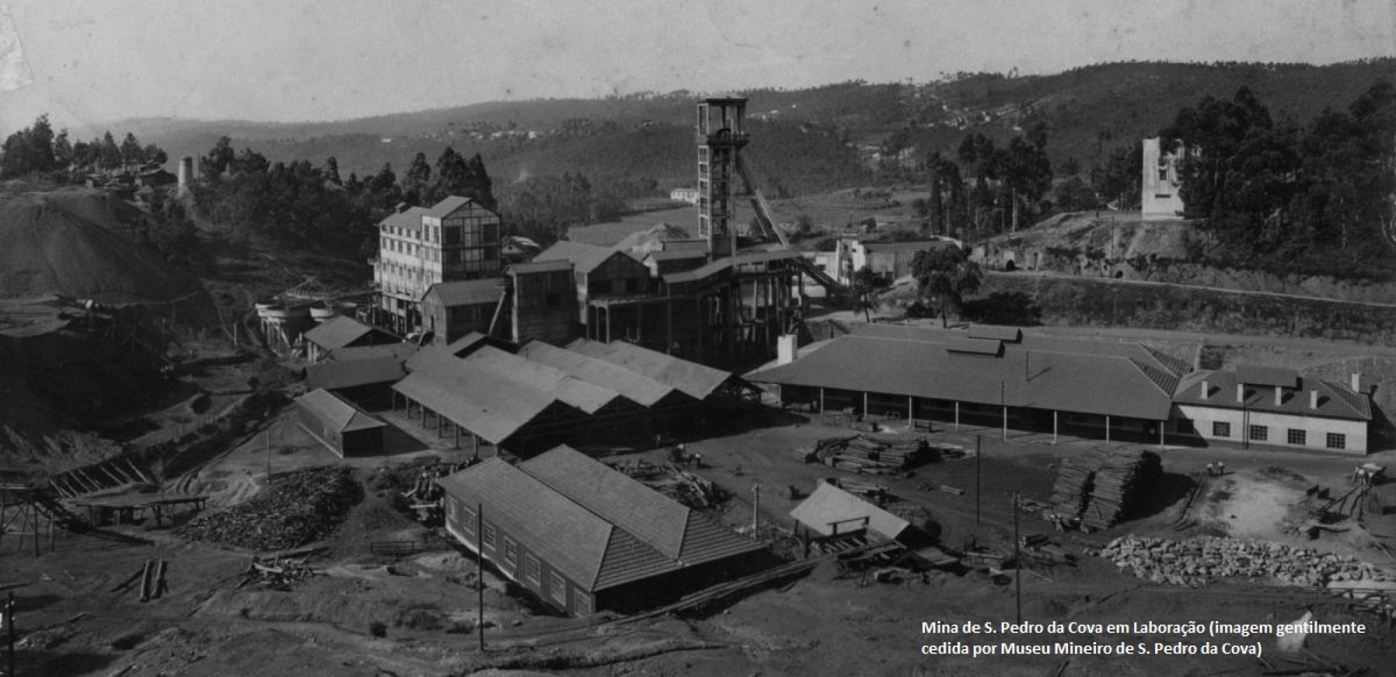
Figure 1. São Pedro da Cova coal mine.
Coal self-combustion can occur during mining or in deposits resulting from exploration. In S. Pedro da Cova, the phenomenon has been monitored in the old waste pile, boosted by large forest fires that took place in 2005 (Figure 1). The coal self-combustion causes the mobilization of pollutants that can be spread through the air or waters and/or be deposited in the soils of the surrounding area, so the study of this theme, framing it in a spatial context, is imperative for the risk analysis for the population and assessment of mitigating measures. The CoalMine Project is a scientific research project that started in 2018, with the ambition to answer some of these questions. The main objectives of the project are related to the characterization and quantification of the environmental impacts caused by the self-combustion of the heap of the old coal mines of S. Pedro da Cova, including the impacts on ecosystems and human health. This is a project funded by the Foundation for Science and Technology through support (co-financing) granted by COMPETE 2020, the European Regional Development Fund and the Portuguese State, within the scope of Portugal 2020.
São Pedro da Cova (Porto, Portugal) coal waste pile have been studied in the last years for the reason that it has been self-burning since 2005 after being ignited by a forest wildfire. Due to its great importance, one international scientific research project, named ECOAL (Ecological Management of Coal Waste Piles in Combustion) was implemented aiming the remote, multi-point, and continuous monitoring of gas emissions and combustion temperature in the self-burning coal waste pile using advanced optical fiber sensing technology (Ribeiro et al., 2017a). The results allowed the study of the dynamic and evolution of the combustion process. A more recent project, named CoalMine, that started in 2018, aimed to characterize and quantify the environmental impacts caused by the self-burning of the coal waste pile, including the potential environmental impacts on ecosystems, including soils, waters, and human health (CoalMine, accessed on 22 July 2022). Previous studies proved to be of prime importance the environmental monitoring of the São Pedro da Cova coal waste pile, as well as that the identification of potential environmental impacts of the surrounding areas is of extreme relevance, including soils, and waters.
In the São Pedro da Cova coal waste pile, several data were acquired from 2019-2021,including Digital Elevation Models (meters), slope (percentage), aspect (degrees) and thermal images (degrees), through distinct methodologies combined in a multi-approach to estimate the environmental impacts of the waste pile. The information acquired by several techniques, namely in situ campaigns, and remote sensing data, through satellite imagery and Unmanned Aerial Vehicle (UAV) sensors, were manipulated and integrated in a GIS open-source application (Coal Mine), developed for QGIS software, focused on describing the spatial distribution of the contaminated area and also characterizing the environmental and health risks. All the data acquired were integrated in the webGIS page.
In order to create a susceptibility map representing the areas that are prone to suffer contamination sourced from the abandoned mine, with particular highlight on the mine waste pile and the underground mining drainage discharge into the hydrographic network, the available environmental data obtained from different sources were incorporated in a GIS software (QGIS) using a Multiple Criteria Decision Making (MCDM) approach to identify the potential zones where contaminants are deposited from the mining waste through multiple pathways such as gravity, wind, and water. The contamination potential was obtained through a Weighted Overlay Method (WOM) composed of five standardized parameters: i) the waste pile location, ii) runoff areas, iii) downstream drainage, iv) the distance from the waste pile, and, v) Normalized Difference Vegetation Index (NDVI). These parameters were selected based on their role in the transport of contaminants in the environment via different ways (e.g., aerial or aqueous). Each parameter was standardized through two techniques: using Analytic Hierarchy Process (AHP) and Fuzzy-AHP approaches. The final parameter weights were determined using pairwise comparisons in the AHP method. Finally, the parameters were aggregated using the WOM method. The maps related to each parameter were projected in the European Terrestrial Refer-ence System (ETRS89)-PTTM06 coordinate system (EPSG:3763) and resampled to 10 meters of spatial resolution (the same resolution as satellite imagery), with the extension of the study area. The methodology adopted and the data used are presented in the next flowchart (Figure 2).
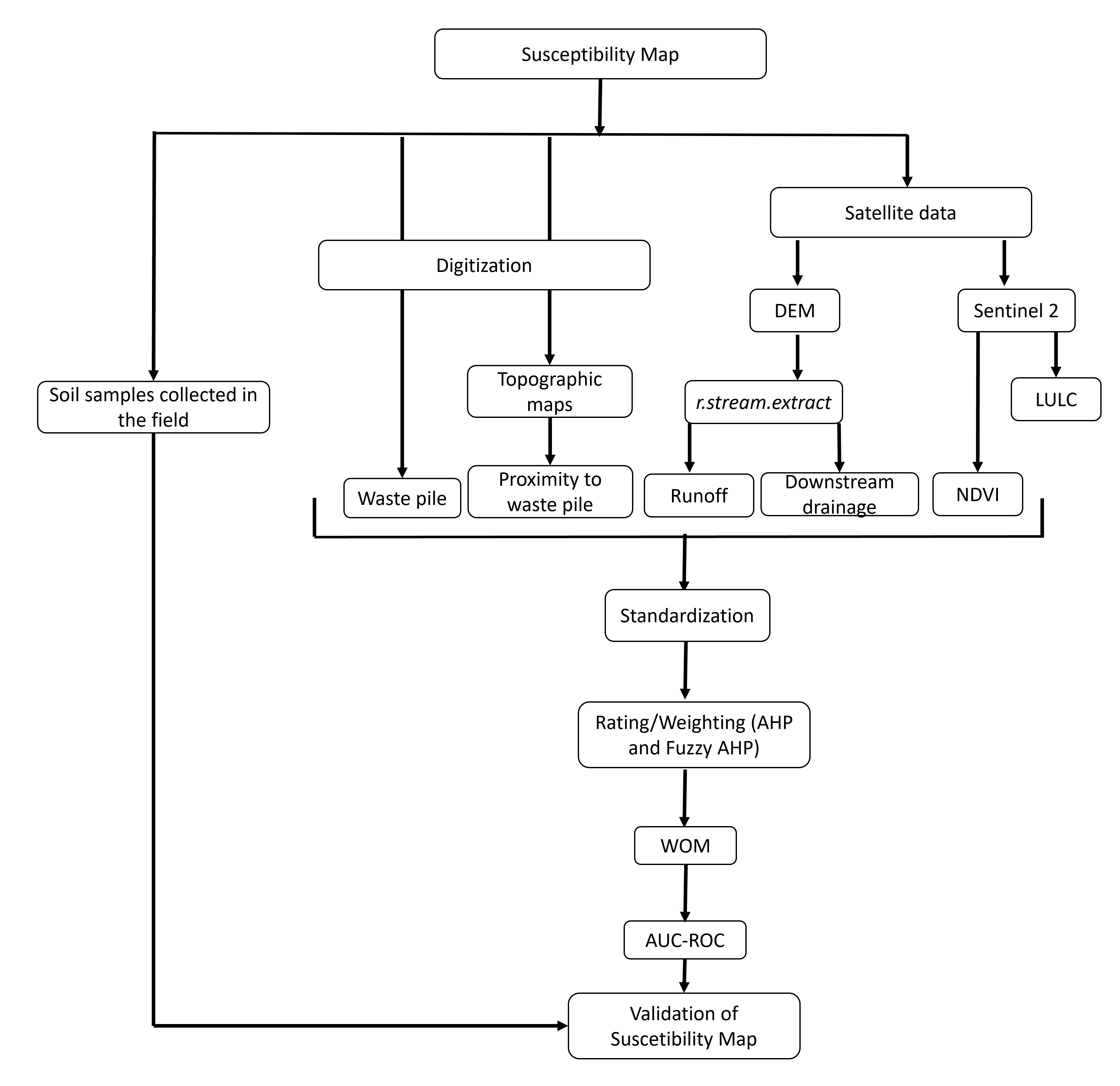
Figure 2. Flowchart presenting the data and methodology used in the prodution of suscetibility map.
The parameter weights were determined based on pairwise comparisons using the AHP process. Five parameters were considered in the mine contamination susceptibility modeling: i) the waste pile, ii) runoff areas, iii) downstream drainage, iv) the distance from the waste pile, and v) the NDVI index. Within the approach used in this study, the comparison of the contributions of each parameter was determined by an expert-based pairwise comparison matrix considering the previous knowledge of the study area, the availability of the data, and the experience of the researchers. The most relevant parameter, with a higher contribution, was the waste pile areas as it is considered a primary source of contamination, followed by the runoff area and drainage network. Aerial dispersion of contaminants from the studied waste pile does not seem as significant as water transportation, as from a first soil geochemical campaign, conducted at the end of the rainy season, to the second campaign, at the end of the dry season, there was a generalized trend for soils surrounding the waste pile, to maintain or moderately reduce the concentrations of trace elements. As expected, in both methods, the zones more suscetptible to mine contamination were identified over the waste pile and in the immediate surrounding areas affected by the runoff. These areas were classified as presenting very high and high susceptibility to mine contamination and are mostly dominated by forest use and there is no urban overlap. The contamination susceptibility ranged from high to moderate along the closest segment of the drainage network from the waste pile and the mine effluents discharge, along these segments there is evidence for agricultural practices and therefore a growing concern with the eventual usage of poor quality water for irrigation purposes. The following segments downstream decrease to low susceptibility as there is a significant dilution on pollutants concentration caused by tributary water input to the drainage lines. A concentric area with approximately 1 km surrounding the waste pile is classified as moderate susceptibility as a reflex of contaminants deposition from the waste pile by areal dissemination. This area affects both urban, agricultural areas and forest. For more information, please contact us.
Martins, V.; Ribeiro, J.; Espinha Marques, J.; Santos, P.; Mansilha, C.; Flores, D. Pedogénese e condutividade hidráulica de um Tecnossolo de uma escombreira de carvão (Mina de São Pedro da Cova, N de Portugal). Anais do XV Congresso de Geoquímica dos Países de Língua Portuguesa, Edição Digital, 2021.
Santos, P.; Ribeiro, J.; Espinha Marques, J.; Flores, D. Distribuição de Elementos Potencialmente Tóxicos nos Solos da Envolvente de uma Mina de Carvão Abandonada no N de Portugal. Anais do XV Congresso de Geoquímica dos Países de Língua Portuguesa, Edição Digital, 2021.
Duarte, L.; Teodoro, A.C.; Fernandes, J.; Santos, P.; Flores, D. An Integrated Environmental Monitoring Approach through the Development of Coal Mine, a GIS Open Source Application. Proceedings of the 6th International Conference on Geographical Information Systems Theory, Applications and Management, Vol. 1, GISTAM, ISBN 978-989-758-425-1, pp. 286-293. DOI: 10.5220/0009578402860293, May 2020. https://www.scitepress.org/PublicationsDetail.aspx?ID=OvvZet7FT+Y=&t=1.
Teodoro, A.C.; Fernandes, J.; Santos, P.; Duarte, L.; Gonçalves, J.A.; Flores, D. Monitoring of soil movement in a self-burning coal waste pile with UAV imagery. Proc. SPIE 11534, Earth Resources and Environmental Remote Sensing/GIS Applications XI, 115340O (20 September 2020); https://doi.org/10.1117/12.2574059.
Teodoro, A.C.; Fernandes, J.; Santos, P.; Duarte, L.; Flores, D. Evaluation of Temperature in a Self -Burning Coal Waste Pile Considering UAV Data and in Situ Measurements. IGARSS 2020 - 2020 IEEE International Geoscience and Remote Sensing Symposium, 2020, pp. 5218-5221, doi: 10.1109/IGARSS39084.2020.9324525.
Ribeiro, J.; Rocha, J.; Santos, P.; Marques, J.E.; Mansilha, C.; Flores, D. Coal mine drainage in an abandoned coal mine in Douro Coalfield. Book of Abstracts 71st. Annual Meeting of the International Committee for Coal and Organic Petrology meeting, pp. 40., September 2019.
Mansilha, C.; Ferreira Melo, A.; Ribeiro, J.; Flores, D.; Queirós, M.; Marques, J.E. Impact of an abandoned coal mine on groundwater chemical features (S. Pedro da Cova, N Portugal). 2nd International Conference Sustainability, Human Geography and Environment, Cracóvia, Polónia, 2018.
Santos, P.; Espinha Marques, J.; Ribeiro, J.; Flores, D. Avaliação ambiental dos solos adjacentes à antiga mina de carvão de São Pedro da Cova. Congresso Ibérico "Solo e Desenvolvimento Sustentável: Desafios e Soluções", Edição Digital, Julho de 2021.
Santos, P.; Espinha Marques, J.; Ribeiro, J.; Rocha, J.; Flores, D. Caracterização Geoquímica dos Solos na Mina Abandonada de São Pedro da Cova. Livro de Resumos das Jornadas do ICT 2020, Universidade do Minho, Braga, pp.32, Fevereiro 2020.
Teodoro, A.C.; Fernandes, J.; Santos, P.; Duarte, L.; Flores, D. Monitorização da temperatura de combustão da escombreira de São Pedro da Cova através de veiculo aéreo não tripulado – Projeto CoalMine. Livro de Resumos das Jornadas do ICT 2020, Universidade do Minho, Braga, pp. 39, Fevereiro de 2020.
Rocha, J.; Marques, J.E.; Ribeiro, J.; Santos, P.; Mansilha, C.; Flores, D. Enquadramento Hidrogeoquímico de Efluentes da Mina de São Pedro da Cova (Gondomar). Extended Abstracts do XII Congresso Ibérico de Geoquímica, Évora, pp. 315-318, Setembro 2019.
Santos, P.; Marques, J.E.; Ribeiro, J.; Rocha, J.; Flores, D. Caracterização da contaminação dos solos da envolvente da escombreira da antiga mina de carvão de São Pedro da Cova. Extended Abstracts do XII Congresso Ibérico de Geoquímica, Évora, pp. 457- 460, Setembro 2019.
Ribeiro, J.; Duarte, L.; Marques, J.E.; Mansilha, C.; Fonseca, R.; Teodoro, A.C.; Gonçalves, J.A.; Flores, D. CoalMine – Coal mining wastes: assessment, monitoring and reclamation of environmental impacts through remote sensing and geostatistical analysis. Livro de resumos das Jornadas do ICT 2018, p 21, Porto, 2018.
ICT – Instituto Ciências da Terra Faculdade de Ciências Rua do Campo Alegre 4169-007 Porto